Gangotri Gaumukh Tapovan Trek
Brief Description
Overview
Region: Uttarkashi District (Uttarakhand)
Trekking Altitude: Max (4463 mtrs)
Grade: Moderate to Tough
Total Trekking Distance: 48 Kms
Best Season: May to June, August to October
Temperature Range: -8°C to 14°C.
Brief Information
If you love the sight of lofty, forbidding peaks rising majestically into the sky, covering your entire line of sight, then there is no other trek like the Gangotri-Gaumukh-Tapovan trek. It gives trekkers the incredible sight of some of the most beautiful peaks in the Himalaya, such as Mt. Shivling, Mt. Meru (also known as Shark Tail), Mt. Thalay Sagar and the Bhagirathi range of peaks. The trek moves along the Bhagirathi river (which forms the Ganga river later after joining with the Alaknanda River at Devprayag) to its origin – Gaumukh, which at 30 kms in length and 2-4 kms wide is one of the largest glaciers in India. The highlights of this trek are the Gangotri temple (the starting point of the trek) which is one of the holy Char Dhams of Hindu worship and the magnificent high altitude meadows of Tapovan and Nandanvan, famed for their panoramic beauty. You are also likely to come across the local wildlife such as mountain goats, the elusive Bharal (blue sheep) and the colourful birds that inhabit the meadows. Keep an eye out for the unique Bhoj Patra (silver birch) trees whose bark peels off easily and was used as parchment in the Vedic era.
Short Itinerary
Day 1: Drive from Delhi to Uttarkashi ( 450 Kms, 10 to 12 hrs), Overnight stay in hotel at Uttarkashi.
Day 2: Drive from Uttarkashi to Gangotri 3046mtrs (95 Kms, 3 to 4 hrs), Overnight stay in hotel/camp at Gangotri.
Day 3: Trek from Gangotri to Bhojbasa 3800mtrs (14Kms,6 to 7 hrs) via Chirbasa 3350mtrs, Overnight camping at Bhojbasa.
Day 4: Trek from Bhojbasa to Tapovan 4463 mtrs via Gaumukh 3,969 mtrs (9 Kms, 4 to 5 hrs), Overnight camping at Tapovan.
Day 5: Trek from Tapovan4463 mtrs to Nandanvan 4,400 mtrs by crossing Gangotri glacier(7 Kms, 4 to 5 hrs), Overnight camping at Nandanvan
Day 6: Trek from Nandanvan 4,400 mtrs to Chirbasa 3350mtrs (13 Kms, 5 to 6 hrs), Overnight camping at Chirbasa.
Day 7: Trek from Chirbasa 3350mtrs to Gangotri 3046mtrs (5 Kms, 2 hrs) and drive to Uttarkashi(95 Kms, 3 to 4 hrs), Overnight stay in hotel.
Day 8: Drive from Uttarkashi to Delhi (450 Kms, 8 to 9 hrs)
Essential: Do's and Don't / Things to Bring / Inclusion and Exclusion (PDF)
Gangotri Gaumukh Tapovan Trek- Fact and Info (PDF)
Gangotri Gaumukh Tapovan Trek - Detailed Itinerary (PDF)
Fact & Info
INTERESTING FACTS/INFORMATION ABOUT THE PLACE
Uttarkashi
Uttarkashi town is the district headquarters of Uttarkashi and is situated along the banks of the river Bhagirathi. It is well known for its ashrams and temples and also because it is home to one of the best Mountaineering Institutes in India – the Nehru Institute of mountaineering. It was named as Uttarkashi (The Kashi or Varanasi of the North) since its topography and location along the banks of the Bhagirathi bears close resemblance to the city of Varanasi that lies along the river Ganga. Uttarkashi is very famous among adventure enthusiasts as it offers white water rafting along with some excellent trekking routes and mountaineering expeditions into the Gangotri region. Uttarkashi is also the site of a couple of hydro electric power project (the Tiloth Power Plant) dams at Maneri (Maneri Dam) and Joshiyari village (Bhali Dam) Uttarkashi is also the biggest town and main centre for trekking supplies and guides for all treks going into the Gangotri and Yamunotri regions.
Gangotri TempleGangotri is a high-altitude town in Uttarkashi district, located at 3,048 meters above sea level on the banks of the holy Bhagirathi river. It is regarded highly as a Holy pilgrimage site on the Char Dham yatra with legend citing it as the place where the river Ganga first descended from the heavens. The current temple here was built in the early 18th century by the Gorkha General Amar Singh Thapa. The temple has a naturally formed submerged rock shivling, which is clearly visible prior to winter as the cold increases causing the waters to recede and make it visible. It is only open during summers, post May, since there is heavy snowfall in the region during winters, preventing easy access to it.
HarsilHarsil (altitude - 7,860 feet) is a small town that lies on the banks of the Bhagirathi River, enroute to Gangotri. The idol of Goddess Ganga is brought down from the Gangotri temple every winter just before it closes, to a village called Mukhba which lies very close to Harsil. The DRDO (Defence Research and Development Organisation) have also established the Defence Agricultural Research Laboratory here and setup a cantonment area. Harsil is also famous for a strange legend – that of “pahari Wilson”, a British Army officer who deserted the army and reached the sleepy hamlet of Harsil where he married a local girl and settled down. He then built himself a fortune out of the trade of skins, fur, musk and later from the timber business. In time, he became more powerful than the Raja of Tehri Garhwal and even minted his own coins! He built himself the sprawling Wilson’s Cottage (which is now in ruins) and the Charlieville Hotel in Mussoorie. The most interesting part of the story is about the ghost of Wilson who comes galloping on full moon nights across a suspension bridge (that he himself had built but is has long since broken off) across the Bhagirathi river.
SuryaKundThis is a spectacular yellowish red sedimentary rock gorge where the river Ganga takes a deep plunge. It is a truly spectacular spot that can be visited as a day trip from Gangotri town.
GaumukhGaumukh glacier is one of the largest glaciers in India, despite its size having shrunk due to global warming. Its length is 30 kms and its width is about 2-4 kms. Its snout looks like the mouth of a cow, which explains the name “Gaumukh” which literally translates to “mouth of a cow”. It is the origin of the Bhagirathi river that later joins with the Alaknanda and forms the holiest river of India, the Ganga. Gaumukh is a massive glacier and has fantastic geological features such as steep rock and ice walls, glacial lakes (tarns), crags, gullies and waterfalls. Most of it lies covered under extensive moraines of mice schist, gneiss, granite and quartz schist. A trip to the Gaumukh glacier is awe-inspiring for its sheer size and also for the beautiful Bhagirathi series of peaks that rise in the background, supplementing its grandeur.
NandanvanNandanvan is a high altitude meadow at approximately 16,000 feet that comes to life in summer with a fresh coat of green grass and a carpet of delightful wildflowers. It is fringed on three sides by massive Himalayan peaks with the most dominant being the Bhagirathi massif. It is also the base camp for expeditions to the Bhagirathi series of peaks.
TapovanTapovan, located near Gangotri in Uttarakhand is a barren plain, that literally translates to a forest for spiritual meditation or penance. It is at a height of approximately 14,640 feet and lies at the feet of Mt. Shivling that completely dominates the horizon. Owing to its magnificient location, it has always been a home to a number of sadhus who meditate here during the summers and hence has acquired the name Tapovan. It is the base camp for expeditions to Mt. Shivling and is also extremely popular among trekkers who camp here before moving onto Nandanvan, a beautiful high altitude meadow further ahead.
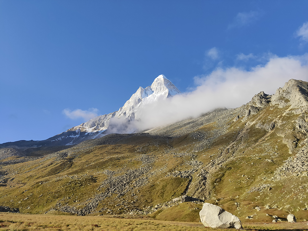
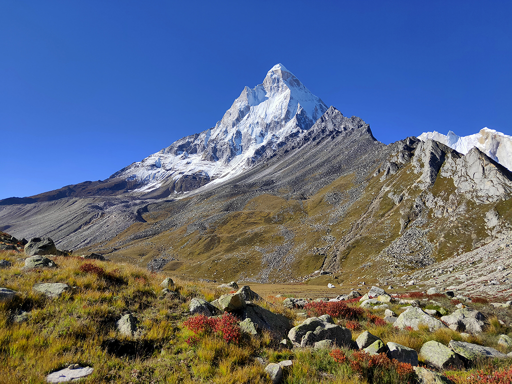
Mt. ShivlingMt. Shivling, at 21,467 feet may not be one of the highest Himalayan peaks, but it is one of most beautiful. It’s conical peak that looks like a Shivling (hence its name) is extremely difficult to climb and has been given the moniker of the “Indian Matterhorn” owing to its striking profile that is similar to Mt. Matterhorn in the European Alps. It juts out as a spur from the ridge line that forms the southwest side of the Gangotri Glacier basin. This ridge line has perhaps the most famous selection of strikingly beautiful peaks, with Mt. Meru ,Mt.Thalay Sagar and the Bhagirathi sister peaks lying along it.
YamunotriThe source of the river Yamuna lies atop a flank of Bandarpoonch mountain at an altitude of 3,293 metres, in the westernmost Garhwal Himalaya. It is also regarded as the seat of Goddess Yamuna and the shrine is named as Yamunotri in her honour. It is a popular pilgrimage location and one of the most important “char dhams” of Hindu Pilgrimage alongwith Gangotri. It is located about 30 kms North of Uttarkashi. The actual source of the river is the Champasar Glacier that is located on the Kalind Mountain, 1 km away from the shrine and almost 500 metres above! (at 4,421 metres). The approach is extremely difficult and dangerous and it is regarded as inaccessible. The deity of the temple is made of black marble and was placed by Maharaja Pratap Shah of Tehri Garhwal. There are a number of hot springs gushing out of the cracks in the mountains here, which pool and form steaming ponds (or “kunds”) The most important among these is the Surya Kund(Hot springs are also found about 7 kms away at a place known as Janki Chatti). The temple closes for winter on Diwali day and reopens in summer on the auspicious day of Akshaya Tritiya.
Gangotri Gaumukh Tapovan Trek- Fact and Info (PDF)
Detailed Itinerary
Day 1: Drive from Delhi to Uttarkashi (450 Kms, 10 to 12 hrs), Overnight stay in hotel at Uttarkashi
We meet in Delhi and begin our drive as early as possible, so that there is some time to explore Rishikesh in the evening. The drive by itself is unspectacular until we come across the holy ghats of Haridwar where we will skirt the wide and swift flowing river Ganga. From this point on, the road gets more interesting with a climb up the wooded foothills of Rishikesh, passing by the various Yoga ashrams and retreats that Rishikesh is known for.
The drive from Rishikesh to Uttarkashi goes through the towns of Narendra Nagar, Mohan Chatti, Tehri, Chamba and Chham. Most of the road is narrow and is pretty much a constant climb until we reach Uttarkashi.
Day 2: Drive from Uttarkashi to Gangotri 3046 mtrs (95 Kms, 3 to 4 hrs), Overnight stay in hotel/camp at Gangotri
We leave Uttarkashi after breakfast and undertake the short drive (3 to 4 hours) along the usual rough Himalayan roads to the holy town of Gangotri. The route goes past the towns of Bhatwari, Haril and Bhaironghati before ending up at Gangotri. It is worth taking a short break at Harsil, which is a pretty town with the pine and deodar forests and the interesting legend of Wilson’s ghost!
About 10 kms before Gangotri, we will come across the town of Bhaironghati (the confluence of the Jat Ganga and the Bhagirathi rivers) where you could stop by and visit the temple of Bhairav Nath nested among the lovely dark coniferous forests. The final stretch to Gangotri begins from here and will not take very long.
Gangotri is famous as the place where the River Ganga (as Bhagirathi) descended from the heavens onto Lord Shiva’s locks and then onto the earth. (The shivling where Shiva is said to have received the river is located at the Gangotri shrine and lies submerged under water. It is partially visible in winters when the water level recedes) We can spend the evening visiting the temple shrine and walk about the town, visiting the Pandav Gufa or the Suryakund, enjoying the scenic views of the snowclad peaks we will be visiting from tomorrow onwards.
Day 3 Trek to Bhojbasa 3800 mtrs (14 Kms,6 to 7 hrs) via Chirbasa 3350mtrs, Overnight camping at Bhojbasa.
Day 4: Trek from Bhojbasa to Tapovan 4463 mtrs via Gaumukh 3,969 mtrs (9 Kms, 4 to 5 hrs) ,Overnight camping at Tapovan.
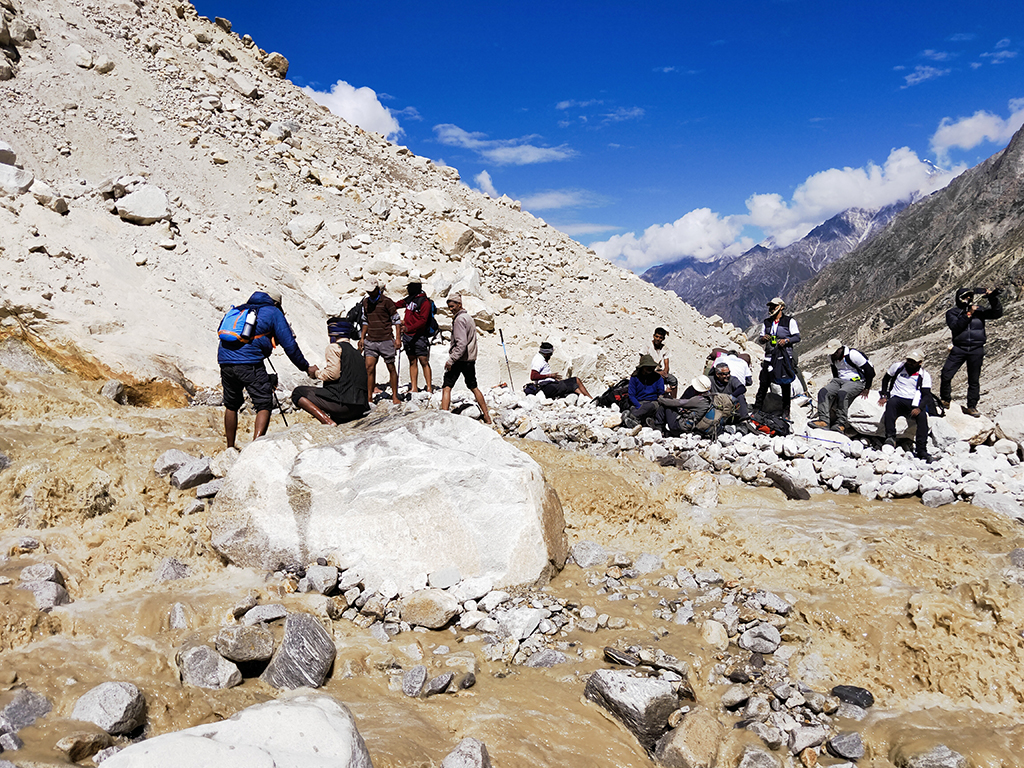
We need to start the day really early today since it is advisable to cross the glacial section near Gaumukh in the mornings. The reason is that the rocks get heated during the day time and thus are prone to shifting and falling down the mountain slopes around afternoon and beyond.
From Bhojwasa, we begin our trek with a gradual climb for about 3 kms towards Gaumukh. As you walk along, you will see boards that indicate the position of the glacier across the decades and it is quite a sobering thought to see how far it has retreated! The route is barren and over boulders surrounded by snowy and rocky peaks.
Half a km before the snout (Gaumukh) we come cross a number of small temples and shrines built by sadhus who worship here. By now we are walking on top of the moraine that hides the glacier and to first timers it seems odd to not find the classic white ice that they imagine. Here the ice is a dull, dirty looking bluish green and you will see pieces of ice floating along the river that is gushing out of its snout. The dull look of the ice is due to the rocks that fall down the slopes of the mountains that encircle this vast amphitheatre like basin and have weathered over a period of time. It is quite amazing to think that this glacial ice was formed over hundreds of thousands of years over a slow process of accumulation!
After crossing Gaumukh we will traverse across the glacier to our left (the true right of the glacier) carefully across the boulders and moraine. This is the location where you need to watch out for falling rocks from the barren mountain slopes above. It is advised to be alert and on the watch, as also to try and cross this section as soon as possible.
Keep jumping across the boulders following the cairns that continue along the left. After about 30-45 minutes on your left, you will see the location of what used to be the Raktavaran glacier, that has now completely broken up! It is also the route up to the needle like Mt. Thelu summit. We will need to keep climbing till we reach the top of the Gaumukh glacier (and this is a steep climb!) where the ridge splits into two with one route leading to Nandanvan and the other leading to our destination.
After crossing the Akash Ganga stream (which can get quick tricky as it gets late in the day due to volume of water) we now come to the last segment with the final steep ascent that will take you to the top of the steep slope ahead and then beyond to Tapovan. This is the most difficult sector of the trek today with the altitude making it extremely difficult to climb up the scree, as also the slippery ice that may look like rock and catch you unawares.
Once this has been crossed, you finally come to the spectacular meadow of Tapovan with the incredible Mt. Shivling towering over us.
If you have energy left, you could take a walk to Neel Tal, a small pond about an hour away, formed by a stream that flows down the Bhrigupanth slope.
Day 5: Trek from Tapovan 4463 mtrs to Nandanvan 4,400 mtrs by crossing Gangotri glacier(7 Kms, 4 to 5 hrs), Overnight camping at Nandanvan.
Today’s trek is also a tough one and members are again advised to not over exert themselves and be alert. We trek back up and along the ridge of the Gangotri glacier with the Bhagirathi peaks giving us company. Nandanvan lies at the base of the Bhagirathi massif and we will take the trail that leads down and to the right from the top of the ridge. Once we are down on the Gangotri glacier, we will continue walking along it. This is a fairly level and is one of the few easy sections in terms of climb but care has to be taken to walk over stable boulders and avoid stepping on ice slabs.
After the traverse, we will look to go towards the base of Nandanvan which lies close to the terminus of the Chaturangi and the Gangotri glacier. The terminus is quite prominent with a semi formed glacial bridge between them.
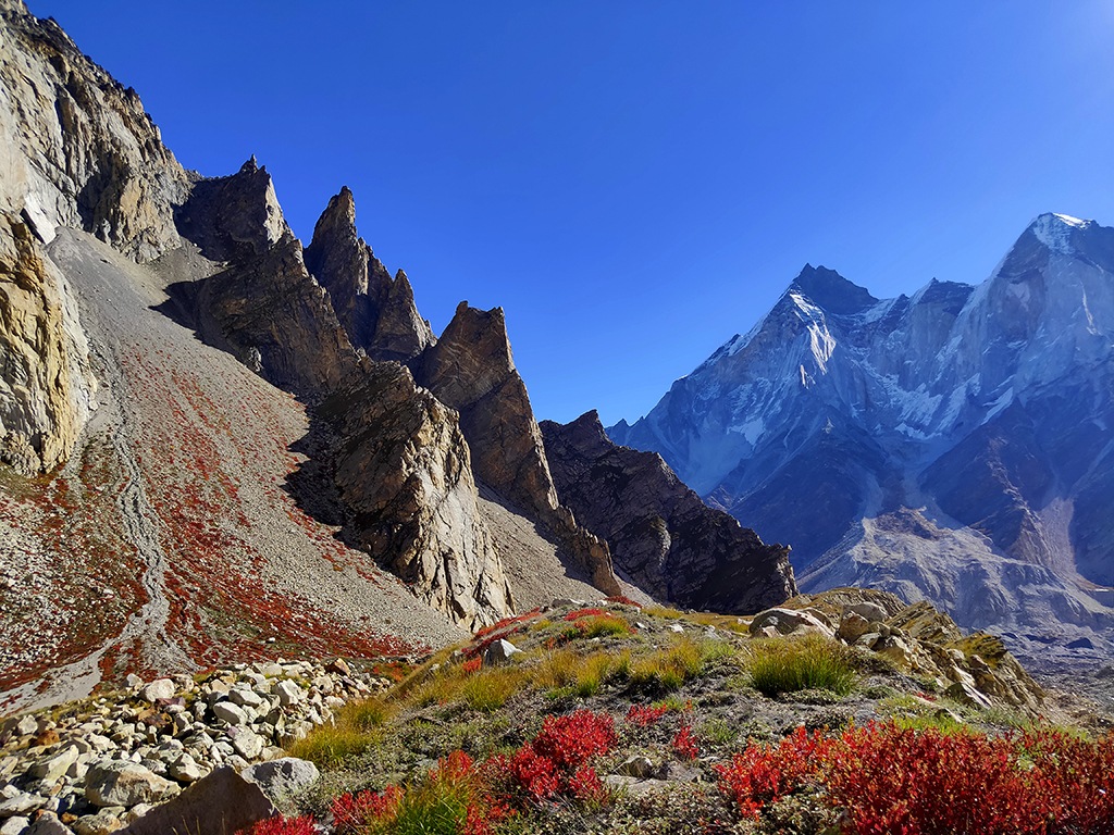
The final approach is quite steep and will take at least an hour to complete. The campsite makes the effort worth it.Lying at the base of Bhagirathi 2, it allows spectacular views of Mt. Shivling, Mt. Meru, Mt. Kedardome and of course the Bhagirathi massif!
Day 6: Trek from Nandanvan 4400 mtrs to Chirbasa 3350 mtrs (13 Kms, 5 to 6 hrs) Overnight camping at Chirbasa.
Once again we will begin the trek early since it is longer than yesterday, although it is considerably easier since we will be descending. The route is pretty much the same, we find our way up past the terminal of the Chaturangi and Gangotri glaciers, until we are back on the ridge. From here, we take the route that leads back on down, skirting past the Gaumukh snout, through the rockfall zone.
Our trail doubles back along the moraine of the glacier and down to Bhojbasa where we had camped before. After a short break, we will proceed further and end the day at the Chirbasa campsite among the treeline.
Day 7: Trek from Chirbasa 3350 mtrs to Gangotri 3046 mtrs (5 Kms, 2 hrs) and Drive to Uttarkashi(95 Kms, 3 to 4 hrs), Overnight stay in hotel.
We again begin trekking early in the morning, since we will be driving to Uttarkashi today itself. The trek is fairly easy and will take us back past the Forest Check Post, down the steps behind the temple and into Gangotri town. After a short break, we will begin our drive down to Uttarkashi again via Harsil.
Day 8: Drive from Uttarkashi to Delhi (450 Kms, 8 to 9 hrs)
From Uttarkashi, we drive down till Dharasu bend, where we will turn left and proceed till Rishikesh. From Rishikesh to Haridwar, we descend along forested slopes, paralleling the river Ganga. The drive from Haridwar onwards to New Delhi is through the plains via Roorkee, Meerut and Ghaziabad and is almost an anti-climax after the beautiful time spent amidst the sublime Himalayan beauty.


